EB23 Inspection Station
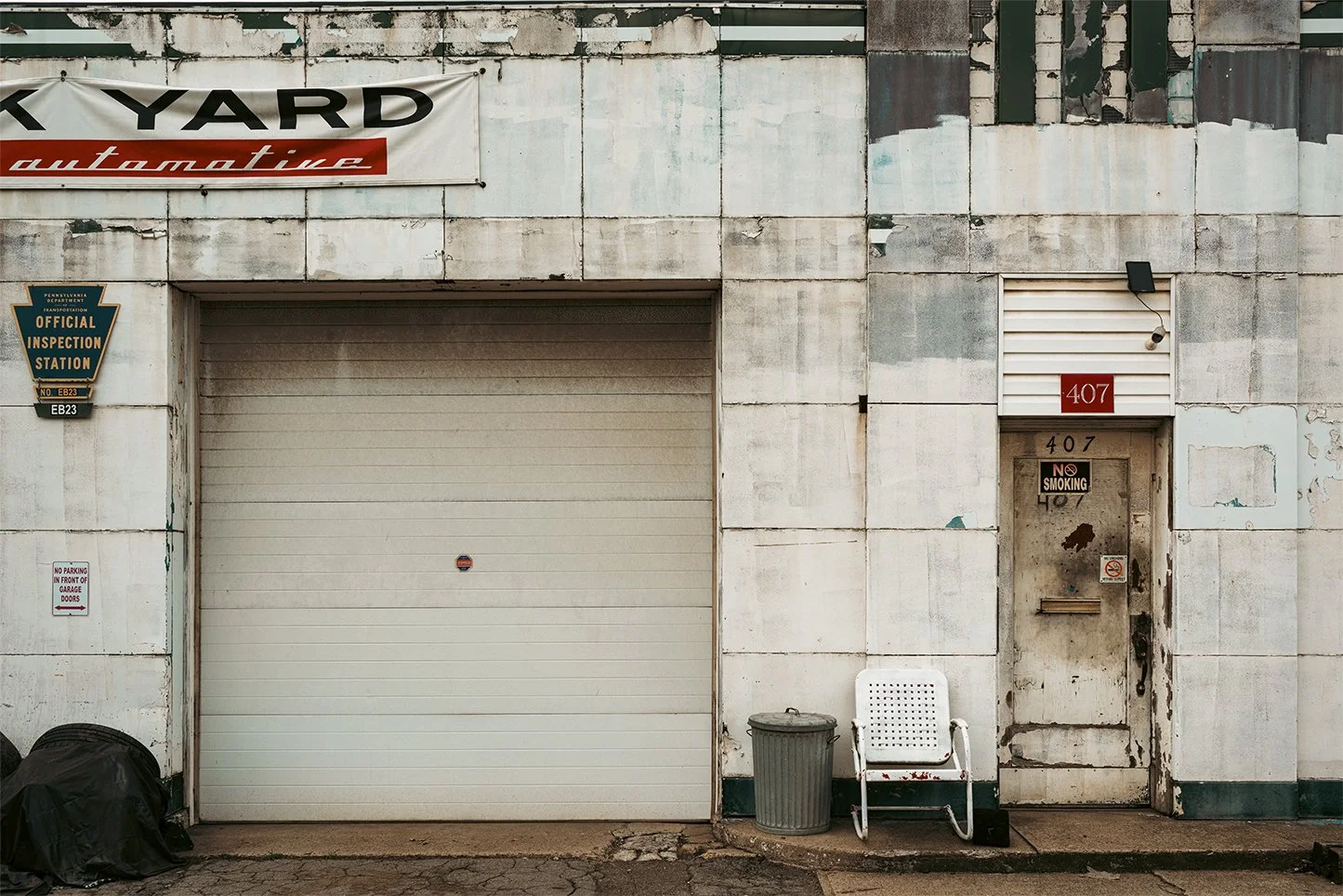
EB23 Inspection Station
Kevin LeDuc
EB23 Inspection Station, c. 1970’s
Clairton, Allegheny County, Pennsylvania from the Ballyshannon’s Rustland (2021–2024) – Flesh and Furnace Portfolio
Pigment print on Hahnemühle Baryta
Artist’s proof + edition of 5 (portfolio of 40 images)
30 × 45 inches
-
Industrial Governance and Environmental Control: The EB23 Inspection Station in Clairton, Allegheny County, Pennsylvania (Revised Edition)
Introduction: EB23 as Regulatory Infrastructure (Post-1970 Formation Context)
The EB23 Inspection Station in Clairton, Pennsylvania, should be understood not as a conventional civic building with a single founding date, but as part of a post-1970 environmental regulatory infrastructure embedded within one of the most heavily industrialized corridors in the United States. Following the creation of the U.S. Environmental Protection Agency (EPA) in 1970 and the implementation of major Clean Air Act amendments, federal and state authorities expanded localized systems of air-quality monitoring, inspection access points, and compliance verification zones across industrial regions such as the Monongahela Valley.
Within this framework, designations such as “EB23” emerged as part of technical monitoring and inspection coding systems used by regulatory agencies and industrial compliance programs. These sites were not typically “opened” in a ceremonial sense; rather, they were installed, upgraded, or reclassified as part of evolving environmental enforcement networks. In the case of Clairton, EB23 is associated with the industrial zone surrounding the Clairton Coke Works, where continuous emissions, dense industrial activity, and proximity to residential neighborhoods necessitated persistent monitoring and inspection infrastructure. As such, EB23 represents a shift in industrial governance from episodic inspection to embedded, continuous environmental oversight within the production landscape itself.
I. The Mon Valley Industrial Landscape and Regulatory Necessity
Clairton developed along the Monongahela River as part of the broader Pittsburgh steel system, anchored by U.S. Steel’s Clairton Coke Works. This facility became the largest coke-processing plant in the United States, supplying fuel for steel production across the region.¹ Its scale and continuous operation made it central to both regional industry and environmental regulation.
By the mid-twentieth century, the Mon Valley was widely recognized as one of the most heavily polluted industrial corridors in the country. Airborne emissions from coke production—including sulfur dioxide and particulate matter—generated sustained environmental and public health concerns.² These conditions later formed the regulatory basis for expanded federal oversight beginning in the 1970s.
II. Emergence of Environmental Monitoring Infrastructure
The creation of the EPA in 1970 marked a structural shift in industrial governance. Regulation moved from largely state-level or intermittent inspection toward continuous monitoring systems embedded within industrial regions.³
In this context, inspection and monitoring designations such as EB23 emerged as part of:
Air quality measurement networks
Industrial compliance inspection routes
Facility-specific monitoring zones
Enforcement documentation systems
Rather than existing as isolated buildings, these stations function as nodes within a distributed regulatory grid spanning industrial corridors.
III. Clairton Coke Works and the Logic of Embedded Oversight
The Clairton Coke Works requires continuous oversight due to its scale and emissions profile. Unlike smaller industrial facilities subject to periodic inspection, Clairton’s operations necessitate ongoing monitoring and rapid response capability.
Inspection infrastructure associated with sites like EB23 reflects this requirement by:
Providing physical access points for inspection personnel
Supporting emissions verification and sampling
Connecting industrial operators with regulatory agencies
Enabling rapid response during environmental exceedances
This creates a condition in which regulation is not external to industry but spatially embedded within it.
IV. Environmental Enforcement and Industrial Accountability
From the late twentieth century onward, Clairton became a focal point of environmental enforcement activity. EPA and Pennsylvania Department of Environmental Protection records document repeated compliance actions related to emissions events and equipment performance at the coke works.⁴
Inspection infrastructure such as EB23 plays a supporting role in this regulatory ecosystem by enabling:
Documentation of emissions conditions
On-site inspection verification
Data collection during enforcement investigations
Coordination between state and federal regulators
Rather than serving a public-facing function, EB23 operates as a technical instrument within environmental governance.
V. Spatial Context: Industrial Density and Residential Proximity
Clairton’s geography intensifies the significance of embedded inspection systems. The city is characterized by extreme proximity between industrial facilities and residential neighborhoods.
Key spatial features include:
River-level industrial complexes along the Monongahela
Hillside residential neighborhoods overlooking industrial zones
Narrow valley geometry concentrating emissions and infrastructure
Limited spatial separation between production and habitation
In this environment, regulatory infrastructure must operate within immediate physical proximity to both industrial and residential spaces, making embedded monitoring systems structurally necessary.
VI. Postindustrial Continuity and Ongoing Industrial Operation
Unlike many former steel cities, Clairton has not fully transitioned out of heavy industry. The Clairton Coke Works remains operational, albeit under increasingly stringent environmental regulation and modernization requirements.
As a result, inspection systems such as EB23 are not relics of a closed industrial past but components of an ongoing regulatory present. They reflect a city where industrial production continues under conditions of continuous environmental oversight.
VII. Neighborhood Context: The Mon Valley Industrial Edge
The neighborhood surrounding Clairton is defined by the Monongahela River industrial corridor. It is characterized by:
Steep topography separating residential and industrial zones
Dense industrial infrastructure along the river floodplain
Long-term environmental monitoring and remediation activity
Aging housing stock tied to steel-era development patterns
A particularly notable feature of this neighborhood is the continuous visual exposure of residential areas to industrial operations. Unlike cities where zoning creates separation between industrial and residential life, Clairton preserves direct sightlines between homes, infrastructure, and emissions sources. This produces a uniquely transparent industrial landscape in which environmental governance is visually embedded in everyday life.
Conclusion
The EB23 Inspection Station in Clairton represents a form of infrastructural governance characteristic of post-1970 environmental regulation: embedded, continuous, and spatially integrated into industrial production systems. Rather than functioning as a standalone civic institution with a fixed founding date, EB23 exists within a dynamic regulatory network shaped by federal environmental policy and the ongoing operation of the Clairton Coke Works.
In this sense, EB23 is not simply a place—it is a function of industrial modernity in its regulated form, where production and oversight occupy the same physical and operational space.
Footnotes (Chicago Style)
U.S. Steel Corporation, Clairton Coke Works operational and historical documentation.
U.S. Environmental Protection Agency, Mon Valley Air Quality and Emissions Reports.
U.S. Environmental Protection Agency, History of the EPA and Clean Air Act implementation.
Pennsylvania Department of Environmental Protection enforcement records; EPA compliance actions for Clairton Coke Works.
Bibliography
U.S. Environmental Protection Agency. Mon Valley Air Quality Reports.
U.S. Environmental Protection Agency. History of Environmental Regulation in the United States.
Pennsylvania Department of Environmental Protection. Industrial Compliance Records: Allegheny County.
U.S. Steel Corporation. Clairton Coke Works Historical Documentation.
Neighborhood Insight (Expanded)
One of the most distinctive features of the Clairton area is its absence of visual separation between industry and residence. Because the city is built along a narrow river valley, homes sit above industrial facilities, creating a constant line of sight between residential life and heavy industry. This produces a rare urban condition in which environmental regulation is not abstract or distant but physically visible—residents live above, and in direct view of, one of the largest coke production facilities in the United States.
-
Steel, Smoke, and River Inequality: The Historical Development of Clairton, Allegheny County, Pennsylvania
Clairton, Pennsylvania, located along the eastern bank of the Monongahela River in southern Allegheny County, is one of the most emblematic industrial river towns in the American steel belt. Its history is inseparable from the rise of Carnegie Steel and its successor U.S. Steel, particularly the massive Clairton Coke Works, which became one of the largest coke-processing facilities in the world. From its origins as a nineteenth-century river settlement to its transformation into a heavily industrialized company town and its present status as a postindustrial community shaped by environmental and economic challenges, Clairton illustrates the full arc of steel-era urbanization in southwestern Pennsylvania.
I. River Geography and Early Settlement
Clairton’s development was fundamentally shaped by its position along the Monongahela River, a navigable waterway that connected the Appalachian interior to Pittsburgh’s industrial core. Early settlement in the area was sparse and primarily agricultural until the mid-nineteenth century, when river transportation and rail expansion made the region attractive for industrial investment.¹
By the late 1800s, the surrounding Mon Valley was rapidly transforming into one of the most concentrated steel-producing regions in the world. Towns along the river were increasingly organized around mills, coke ovens, and rail lines, with settlement patterns dictated by industrial proximity rather than traditional civic planning.
II. Industrialization and the Rise of Company Influence
Clairton’s industrial identity began to solidify in the early twentieth century when Carnegie Steel (later U.S. Steel) expanded coke production in the region. Coke—processed coal used in steelmaking—became essential to the Pittsburgh district’s dominance in global steel production.
The construction and expansion of the Clairton Coke Works in the early 1900s marked a turning point in the city’s history.² The facility eventually became the largest coke-producing plant in the United States, anchoring Clairton’s economy and shaping nearly every aspect of civic life, from employment patterns to housing development.
As in many Mon Valley towns, Clairton functioned effectively as a company-influenced industrial city. While not formally a company town in the strict legal sense, its economy, infrastructure, and labor market were overwhelmingly dependent on a single industrial employer.
III. Immigrant Labor and Urban Formation
During its industrial expansion, Clairton attracted waves of immigrant laborers from Southern and Eastern Europe, including Slovak, Italian, Polish, Croatian, and Hungarian communities.³ These populations settled in dense neighborhoods near the mills and riverfront industrial zones.
Ethnic institutions played a critical role in structuring community life. Catholic parishes, fraternal organizations, and mutual aid societies provided spiritual support, financial assistance, and social cohesion. Churches such as St. Clare of Assisi Parish became central anchors of neighborhood identity, reinforcing ethnic continuity while integrating immigrant populations into American industrial labor systems.⁴
Housing in Clairton developed rapidly and often informally, producing tightly packed residential blocks on steep hillsides overlooking the river and industrial facilities below.
IV. The Industrial Peak: Coke Production and Environmental Transformation
By the mid-twentieth century, Clairton had become synonymous with industrial intensity. The Clairton Coke Works expanded significantly under U.S. Steel, producing coke for steel mills throughout the Pittsburgh region.
This industrial dominance came with severe environmental consequences. Coke production released substantial air pollution, including sulfur compounds and particulate matter, making the Mon Valley one of the most heavily polluted industrial regions in the United States during the mid-twentieth century.⁵ The visual landscape of Clairton became defined by smokestacks, river barges, rail traffic, and dense industrial infrastructure.
Despite these conditions, employment in the mills provided economic stability for many families, reinforcing dependence on the steel industry.
V. Decline of Steel and Economic Contraction
Beginning in the late 1970s and accelerating through the 1980s and 1990s, the American steel industry entered a period of structural decline due to global competition, automation, and industrial relocation. While the Clairton Coke Works remained operational, employment levels dropped significantly, and the broader Mon Valley experienced severe economic contraction.
Clairton’s population declined, housing values fell, and municipal revenues decreased.⁶ The city, once defined by industrial expansion, became emblematic of postindustrial shrinkage in the American Rust Belt.
VI. Environmental Regulation and Industrial Survival
Unlike many steel facilities that closed entirely, the Clairton Coke Works persisted into the twenty-first century, albeit under increasing environmental regulation. The facility has been subject to repeated scrutiny by the Environmental Protection Agency due to air quality violations and emissions concerns.⁷
Despite this, it remains operational, making Clairton a rare example of a postindustrial city that still hosts large-scale heavy industry within its boundaries. This dual identity—industrial persistence amid urban decline—defines Clairton’s contemporary condition.
VII. Neighborhood Structure and Urban Form
Clairton’s neighborhood structure reflects its industrial origins. Residential areas are organized along steep hillsides rising from the river valley, with working-class housing historically clustered near industrial sites. Commercial corridors developed along main roads connecting the city to neighboring Mon Valley communities such as McKeesport and Glassport.
One of the most notable features of Clairton’s urban form is the vertical separation between residential life and industrial production: homes sit above the valley floor, while mills and coke works occupy the riverbank. This spatial arrangement created both physical and social distance between daily life and industrial labor.
VIII. Interesting Neighborhood Feature: The “Layered River City” Effect
An especially interesting aspect of Clairton is what urban geographers often describe as a “layered river city” structure. Because the Monongahela River valley is narrow and constrained, infrastructure is stacked rather than spread out:
Riverfront: heavy industry (coke works, rail spurs, barge traffic)
Mid-slope: commercial corridors and older industrial housing
Hilltops: residential neighborhoods and civic institutions
This vertical layering creates a unique visual and spatial experience where industrial infrastructure is constantly visible from residential areas, reinforcing the close relationship between daily life and industrial production even after employment declines.
Conclusion
Clairton, Pennsylvania, embodies the full trajectory of American industrial urbanism: from river-based settlement to steel-driven expansion, from immigrant labor city to environmental and economic contraction. Its identity remains anchored by the Clairton Coke Works, one of the last major industrial facilities of its kind still operating in the United States. At the same time, its residential neighborhoods and civic structures reflect the enduring legacy of immigrant labor communities that built and sustained the region’s industrial economy.
Clairton is therefore not simply a postindustrial city; it is a city where industrial history remains active, visible, and structurally embedded in the landscape itself.
Footnotes (Chicago Style)
Encyclopaedia Britannica, “Monongahela River,” accessed 2026.
U.S. Steel historical archives, Clairton Works industrial development records.
Pennsylvania Historical and Museum Commission, immigrant labor in the Mon Valley.
St. Clare of Assisi Parish historical records, Clairton, PA.
U.S. Environmental Protection Agency, Mon Valley air quality and industrial emissions reports.
U.S. Census Bureau, Clairton population and economic data, 1950–2020.
Environmental Protection Agency enforcement and compliance records for Clairton Coke Works.
Bibliography
Encyclopaedia Britannica. “Monongahela River.”
Environmental Protection Agency. Mon Valley Air Quality Reports.
Pennsylvania Historical and Museum Commission. Immigration and Industry in Western Pennsylvania.
U.S. Census Bureau. Clairton Demographic and Economic Data.
U.S. Steel Corporation. Clairton Works Historical Documentation.
St. Clare of Assisi Parish Archives. Parish History of Clairton, PA.
-
Three Forms of the Steel Belt: Clairton, Johnstown, and Allentown as Industrial Urban Systems in Pennsylvania
The industrial cities of Pennsylvania’s steel belt—Clairton, Johnstown, and Allentown—developed through related but distinct relationships to geography, labor, and infrastructure. While all three were shaped by nineteenth- and twentieth-century industrialization, each reflects a different spatial logic of American heavy industry: Clairton as a river-valley coke city, Johnstown as a constrained floodplain steel city, and Allentown as a rail corridor and mixed-industrial hub. Together, they form a comparative lens through which to understand the rise, transformation, and partial persistence of industrial urbanism in the northeastern United States.
I. Clairton: The River-Industrial Extraction City
Clairton, located along the Monongahela River in Allegheny County, represents the most vertically integrated industrial form of the three cities. Its identity is anchored by the Clairton Coke Works, a massive facility historically operated by U.S. Steel that processed coal into coke for steel production.¹
Clairton’s geography shaped its industrial destiny. The narrow river valley forced industry to the floodplain and residential areas up the surrounding hillsides, producing a sharply stratified urban form:
Riverfront: heavy industry and rail infrastructure
Mid-slope: working-class housing
Hilltops: civic and residential zones
This vertical arrangement produced a constant visual and environmental proximity between labor and production. Clairton is therefore best understood as an extractive processing city, where raw materials were transformed at massive scale within a tightly confined valley system.
Its continued operation into the twenty-first century also makes Clairton unusual: it remains partially industrial while simultaneously experiencing population decline and environmental regulation pressures.²
II. Johnstown: The Floodplain Steel City
Johnstown, in Cambria County, represents a different industrial logic: the floodplain steel city, shaped by confluence geography and repeated environmental catastrophe. Situated at the meeting point of the Conemaugh River and Stony Creek, Johnstown developed around the Cambria Iron Works and later Carnegie Steel operations.
Unlike Clairton’s vertical stratification, Johnstown’s industrial geography is horizontal but constricted:
River confluence floor: steel mills and rail infrastructure
Adjacent neighborhoods: dense immigrant housing
Surrounding hills: expansion-limited residential zones
Johnstown’s defining feature is its vulnerability. The 1889 flood, one of the most devastating disasters in U.S. history, destroyed much of the city and killed over 2,000 people.³ This event permanently embedded environmental risk into the city’s identity.
Industrial labor in Johnstown was heavily immigrant-based, with large populations of Polish, Slovak, Italian, and Hungarian workers forming tightly knit ethnic neighborhoods such as Cambria City and the South Side. These neighborhoods were structured around parish churches and fraternal halls, many of which still survive today in adapted forms.
Johnstown thus represents a catastrophe-shaped industrial city, where geography, industry, and disaster are inseparable.
III. Allentown: The Rail Corridor Industrial City
Allentown, in the Lehigh Valley, represents the third model: the rail corridor industrial city, shaped less by a single dominant mill or river extraction system and more by competing transportation infrastructures.
During the nineteenth and early twentieth centuries, Allentown developed around two major railroad systems:
The Lehigh Valley Railroad
The Central Railroad of New Jersey (CNJ)
These parallel networks produced a dual-core transportation city, with passenger stations, freight yards, and industrial corridors embedded within the urban grid.⁴ Unlike Clairton or Johnstown, Allentown’s industrial structure was not singular but distributed across competing corporate systems.
Its industrial geography included:
Passenger rail stations near Hamilton Street
Freight corridors along Linden Street
Light and medium manufacturing tied to rail logistics
As rail transportation declined in the mid-twentieth century, many of these infrastructures were abandoned or repurposed. One notable example is the former CNJ passenger station, later reused for a sequence of restaurants and nightlife venues, culminating in Banana Joe’s in the early 2000s.⁵ This adaptive reuse reflects Allentown’s shift from industrial mobility hub to postindustrial service and entertainment economy.
IV. Comparative Industrial Logics
Although all three cities belong to the same regional industrial system, their internal structures differ significantly:
1. Production Function
Clairton: coke processing (intermediate industrial transformation)
Johnstown: steel manufacturing (heavy industrial production)
Allentown: transportation and logistics (industrial circulation)
2. Geographic Constraint
Clairton: vertical river valley stratification
Johnstown: floodplain confinement with disaster exposure
Allentown: distributed rail corridors within urban grid
3. Urban Form
Clairton: stacked industrial-residential layering
Johnstown: dense ethnic neighborhoods adjacent to mills
Allentown: fragmented industrial nodes embedded in city fabric
4. Postindustrial Outcome
Clairton: partial industrial continuity (coke works still active)
Johnstown: industrial collapse with heritage persistence
Allentown: adaptive reuse into commercial and cultural spaces
V. Ethnic Labor and Institutional Continuity
Across all three cities, immigrant labor played a central role in industrial development. However, the institutional outcomes diverged:
Johnstown preserved strong parish and fraternal continuity (e.g., Casimir Cultural Center lineage)
Clairton’s institutions were more directly tied to industrial employment cycles
Allentown’s institutions were more dispersed and later converted into commercial or cultural reuse spaces
Despite these differences, all three cities demonstrate how immigrant communities built durable social infrastructures—churches, halls, and mutual aid systems—that often outlasted the industries that created them.
VI. The Postindustrial Transition
The decline of American steel and rail industries in the late twentieth century affected all three cities but in different ways:
Johnstown experienced severe population loss and economic contraction
Allentown transitioned toward service, logistics, and redevelopment economies
Clairton retained industrial activity but with diminished labor force and increased environmental regulation
This divergence illustrates that “deindustrialization” is not a uniform process but a differentiated restructuring of industrial space, shaped by geography and infrastructure type.
VII. Interesting Comparative Insight: The Visibility of Industry
One of the most revealing contrasts among the three cities is the visibility of industry in daily life:
In Clairton, industrial infrastructure remains constantly visible from residential areas due to vertical valley geography.
In Johnstown, industrial remnants are partially obscured by floodplain reorganization and suburban drift, though historic districts preserve memory.
In Allentown, industrial infrastructure has been most thoroughly repurposed or erased, replaced by commercial corridors and redevelopment zones.
This makes Clairton the most “physically continuous” industrial landscape, Johnstown the most “historically memorialized,” and Allentown the most “re-coded.”
Conclusion
Clairton, Johnstown, and Allentown represent three distinct urban expressions of the American steel belt. Each city reflects a different relationship between geography and industrialization: extraction, production, and circulation. Their postindustrial trajectories further diverge, producing varied outcomes of continuity, memory, and transformation.
Taken together, they illustrate that the American industrial landscape was never uniform. Instead, it was a network of specialized urban systems, each shaped by its own geography, infrastructure, and social formation—and each continuing to evolve long after the peak of steel and rail dominance.
Footnotes (Chicago Style)
U.S. Steel historical records, Clairton Coke Works documentation.
U.S. Environmental Protection Agency, Mon Valley industrial emissions reports.
National Park Service, “Johnstown Flood of 1889” historical overview.
Encyclopaedia Britannica, “Allentown, Pennsylvania” industrial and transportation history.
Wikipedia, “Allentown station (Central Railroad of New Jersey)” redevelopment history.
Bibliography
Encyclopaedia Britannica. “Allentown, Pennsylvania.”
Environmental Protection Agency. Mon Valley Air Quality Reports.
National Park Service. Johnstown Flood National Memorial Historical Overview.
U.S. Steel Corporation. Clairton Works Historical Records.
Wikipedia. “Allentown Station (Central Railroad of New Jersey).”