Steamboat Bridge, c. 1897-1903
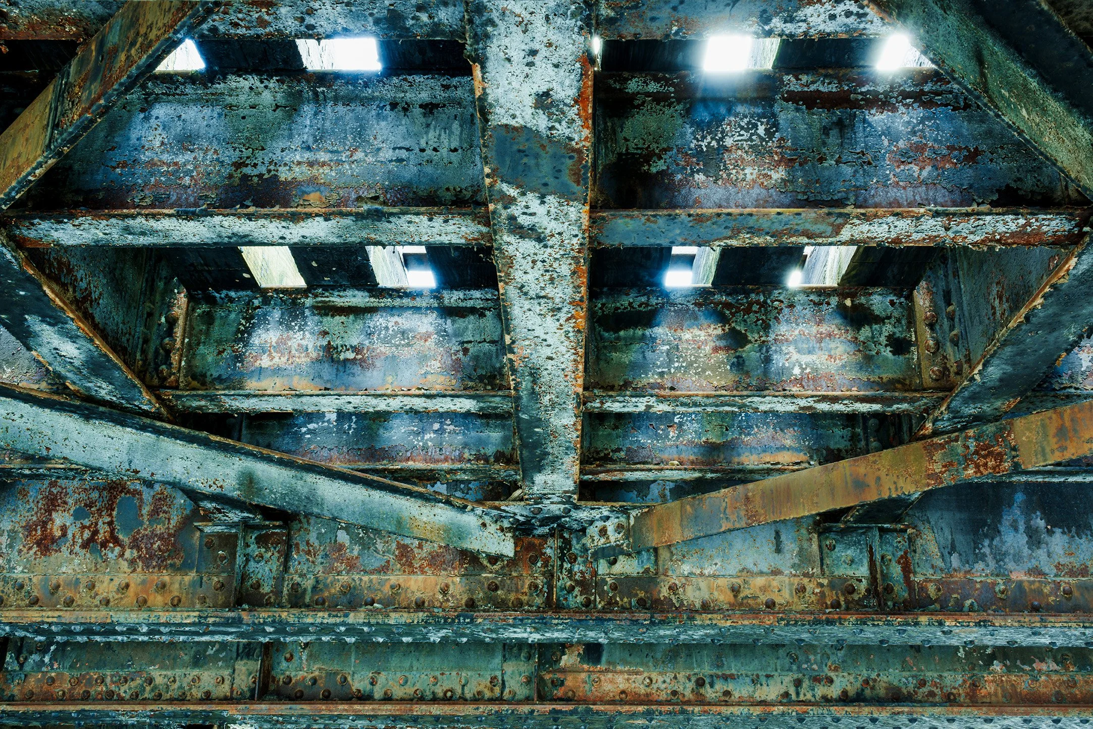
Steamboat Bridge, c. 1897-1903
Maine Central Railroad, c. 1878–1920
Steamboat Lane, Water Street, Waterfront Park
Gardiner, Kennebec County, Maine
From the Echoes, Still: Maine's Industrial Remnants Collection (2024–2028) Machinery Portfolio
Historical Narrative
Gardiner’s Waterfront Railroad: Maine Central and Steamboat Lane Bridge, 1878–1920
Kevin LeDuc Pigment print on Hahnemühle Baryta Edition of 5 + 1 Artist's Proof (Portfolio of 40 Images)
Paper Size: 40 × 55 inches Image Size: 31.33 × 37 inches Borders: Approximately 4 inches (All Sides)
Historic Significance
The Steamboat Lane Bridge was an important component of the Maine Central Railroad’s expanding waterfront system in Gardiner, Maine. The stone bridge carried two railroad tracks over Steamboat Lane, which was approximately twenty feet wide, while the tracks continued along a roughly twelve-foot-high trestle beside the Kennebec River. The bridge appears to have been constructed between approximately 1897 and 1903, based on the Sanborn map sequence. The broader elevated trestle system, however, was already present by 1892, making the bridge part of an earlier process of railroad expansion and waterfront development rather than an isolated construction project.
The waterfront changed substantially between 1878 and 1892. The July 1878 Sanborn map shows the area before the later concentration of railroad and commercial facilities. By 1884, the Maine Central Railroad had two sets of tracks extending along the Kennebec River and was directly serving businesses such as Haley’s Ice House and the Bradstreet Lumber Mill. Bradstreet’s mill used elevated tramways to move materials between the railroad, mill, and riverbank. By 1892, the railroad had expanded to four tracks and served locomotive stalls, coal sheds, A. H. Potter’s coal facilities, J. B. Dingley & Brothers’ coal warehouse, an ice house, freight facilities, and a steamboat passenger depot.
The raised trestle system allowed the Maine Central to maintain continuous railroad movement along the waterfront while commercial activity continued below and beside the tracks. The 1892 Sanborn map already identifies a raised bridge leading onto a twelve-foot-high trestle, while the later 1903 and 1910 maps document the development of the Steamboat Lane crossing. By 1904, a Maine railroad survey specifically identified Steamboat Street as passing beneath the Maine Central trestle. By 1910, the completed arrangement included the stone bridge, two railroad tracks, the Locomotive House, coal sheds and trestles, a 200-foot riverfront freight house, and the Steamboat Passenger Station.
By 1920, the Steamboat Lane Bridge and elevated railroad formed part of a highly integrated rail-and-river transportation district. The Maine Central connected Gardiner’s commercial businesses directly with regional markets while the Kennebec River provided an important route for coal, freight, and passengers. The bridge therefore represents more than a transportation crossing: it illustrates how the Maine Central adapted its infrastructure to the growing demands of Gardiner’s industrial waterfront. The surviving maps provide a strong basis for dating the Steamboat Lane Bridge to approximately 1897–1903, while showing that the larger waterfront trestle system had already developed by 1892.
Historical Narrative
-
The Maine Central Railroad, Steamboat Lane Bridge, and the Development of Gardiner’s Kennebec River Waterfront, 1878–1920
The history of Gardiner’s Kennebec River waterfront between 1878 and 1920 is, in large measure, a history of transportation infrastructure. The Maine Central Railroad did more than provide passenger service: it became the organizing framework through which coal, lumber, ice, manufactured goods, and other commercial commodities moved between the river, the city, and the broader New England rail network. The surviving evidence shows a waterfront that changed from a relatively open river edge in the late 1870s into a dense intermodal district containing railroad tracks, elevated trestles and tramways, coal warehouses, ice houses, freight facilities, locomotive stalls, and steamboat passenger facilities. The Sanborn Fire Insurance maps are especially valuable because they record these changes at short intervals and identify not only buildings but also the physical relationships between railroad tracks, businesses, streets, wharves, and the river.¹
Gardiner had received railroad service in 1852, making it one of the early railroad-connected communities on the Kennebec.² The Maine Central Railroad itself emerged from the consolidation and development of several earlier Maine railroads and became the dominant railroad system serving central and northern Maine.³ By the late nineteenth century, the railroad's importance to Gardiner was inseparable from the city's position at the head of navigation on the Kennebec. An 1886 description of Gardiner specifically noted that the Maine Central Railroad ran “through the length” of the city along the river, while Gardiner remained connected by steamboat with Boston.⁴ The railroad therefore occupied a unique position between land and water transportation. Its tracks could bring freight directly to waterfront businesses, while steamboats could carry bulk commodities and passengers along the Kennebec and beyond.
The July 1878 Sanborn map provides an important baseline for this development. The portion of the waterfront examined in this study had not yet acquired the dense railroad-commercial landscape shown on later maps.⁵ By November 1884, however, the transformation was well underway. The Maine Central had two sets of tracks running along the Kennebec waterfront, and those tracks directly served commercial and industrial properties. Haley's Ice House occupied a substantial three-story wooden building, while the Bradstreet Lumber Mill had established a much more elaborate system of material transfer. Two approximately twenty-foot-high tramways on trestles connected the railroad tracks with the mill: one entered the sawmill directly, while the second led to a raised platform from which three additional elevated tramways extended toward the riverbank. The mill itself contained a brick engine building with six steam engines, including a 350-horsepower engine, and a sixty-five-foot chimney.⁶ The arrangement demonstrates that the railroad was already functioning as an industrial distribution system, not simply as a passenger line or through route.
The January 1892 Sanborn map shows an even more remarkable expansion. Four Maine Central tracks entered the waterfront district. One ended at the locomotive stalls and coal shed; another curved westward toward Water Street and the area that would become associated with Steamboat Lane; while two additional tracks continued northward before converging into a single waterfront track. That track approached a raised bridge and a twelve-foot-high trestle.⁷ The importance of this observation is considerable. It demonstrates that an elevated railroad system was already part of Gardiner's waterfront infrastructure by 1892. The later twelve-foot trestle seen on the 1910 map should therefore not be interpreted as a completely new structure constructed around 1900. Instead, the evidence points toward a process of extension, reconstruction, and reconfiguration of an existing elevated railroad system.
By 1892 the waterfront had also become a major commercial coal terminal. The Sanborn map identifies the coal houses of A. H. Potter and J. B. Dingley & Brothers, each occupying multiple wooden structures. The Dingley operation consisted of four buildings, while the Potter operation likewise occupied four buildings. Nearby were locomotive stalls and a coal shed, together with a storehouse, ice house, and additional coal shed along the wharf. At the river itself stood a two-story Steamboat Passenger Depot and Freight House.⁸ This concentration of facilities demonstrates how closely the Maine Central's railroad operations were tied to Gardiner's commercial economy. Coal could arrive by water, be handled at waterfront facilities, and then be distributed by rail; lumber and other commodities could move in the opposite direction; locomotives themselves required coal; and passengers could transfer between railroad and steamboat transportation.
The elevated trestle and tramway system was an important technological component of this waterfront economy. The 1884 Bradstreet Mill arrangement shows that private industries were already using elevated wooden structures to move materials between railroad tracks, buildings, platforms, and the river. By 1892, the Maine Central itself had incorporated a raised railroad structure into the waterfront circulation system. The elevated alignment provided a practical means of maintaining railroad movement while permitting streets, industrial activity, and waterfront access to function below. The railroad thus became a three-dimensional infrastructure: tracks occupied the upper level, while streets and industrial movements operated beneath and alongside them. This arrangement ultimately produced the distinctive Steamboat Lane underpass.
The precise construction date of the Steamboat Lane Bridge remains uncertain, but the documentary sequence allows a reasonable estimate. The 1892 map already shows an elevated bridge and twelve-foot trestle elsewhere within the waterfront railroad system, while the May 1897 Sanborn map shows railroad track at the Steamboat Lane location without depicting the later stone bridge in the same form.⁹ By July 1903, the later elevated configuration is present. A September 1904 railroad survey provides independent confirmation: the proposed street railway route was specifically described as passing under the Maine Central Railroad trestle in the Steamboat Street area.¹⁰ By the February 1910 Sanborn survey, the arrangement is unmistakably established: Steamboat Lane was approximately twenty feet wide and passed beneath a stone bridge carrying two sets of railroad tracks, with those tracks supported along the waterfront on a trestle approximately twelve feet above grade.¹¹
On the evidence presently available, therefore, the most reasonable estimate is that the Steamboat Lane Bridge was constructed or substantially reconstructed approximately between 1897 and 1903, probably as part of a larger modification of the existing waterfront railroad system. This should be distinguished from the original construction date of the broader waterfront trestle system, which clearly predates 1897 and was already documented in elevated form in 1892. The bridge itself appears to have been the masonry component required where the elevated railroad crossed the established street corridor. The 1904 survey confirms that the trestle was already standing by that date, while later proceedings concerning an electric railway underpass show that the railroad's elevated position had become a permanent feature of the waterfront transportation landscape.¹²
The 1900–1901 Railroad Commissioners' reports are useful for understanding the broader Maine Central context. They emphasize the railroad's continuing program of track, bridge, and infrastructure improvements and describe the Gardiner trestle as an exception to the predominantly iron and steel bridges on the Portland–Bangor main line.¹³ The Gardiner railroad system was therefore not static. It was being continually maintained and adapted as traffic increased. This is consistent with the Sanborn sequence, which shows the Gardiner waterfront evolving from two tracks in 1884 to four tracks and extensive switching arrangements by 1892, followed by the increasingly specialized railroad-commercial complex documented in the early twentieth century.
By 1910, the waterfront had reached a highly integrated stage. The Maine Central's two-track elevated line extended along the Kennebec River, while the Steamboat Lane bridge provided a controlled crossing beneath it. Nearby were the Locomotive House, coal facilities belonging to A. C. Atkins and Mrs. A. E. Dingley, multiple coal trestles, a large coal shed, and a roughly 200-foot freight house on the river. The Steamboat Passenger Station remained part of the same transportation complex.¹⁴ The scale of the coal facilities is particularly revealing. Coal was fundamental to both industrial and railroad operations, and the waterfront provided the ideal location for receiving bulk shipments by vessel and distributing them by rail. The Dingley family's involvement in mechanized coal handling extended even further back: a 1875 advertisement for Hunt's coal-handling machinery directed customers to see the equipment operating at Dingley Brothers in Gardiner.¹⁵
The importance of the Maine Central to Gardiner's commercial businesses continued into the 1910s. The railroad provided direct service to waterfront industries while simultaneously linking Gardiner with regional markets. Its freight infrastructure supported coal dealers, lumber interests, ice dealers, mills, merchants, and steamboat operators. The railroad also supported the city's passenger economy. The nineteenth-century passenger station was ultimately replaced by the handsome 1911 Maine Central station, located overlooking the Kennebec River.¹⁶ The construction of the new station illustrates the continuing importance of rail transportation even as the waterfront infrastructure became more specialized. By this time Gardiner possessed a transportation landscape in which railroad, river, industrial, and commercial functions were tightly interwoven.
The period ending around 1920 thus represents the culmination of a four-decade transformation. In 1878, the waterfront area under examination was comparatively undeveloped. By 1884, the Maine Central tracks were already serving major industrial users such as Bradstreet's lumber mill and Haley's Ice House. By 1892, four railroad tracks, elevated trestles, locomotive facilities, coal warehouses, ice houses, freight facilities, and a steamboat depot had created a substantial transportation terminal. During the 1890s and early 1900s, this system was further reorganized, producing the Steamboat Lane crossing and the stone bridge that allowed the street to pass beneath the two-track elevated railroad. By 1910, the waterfront had become a mature rail-and-river freight and passenger complex, and by 1920 it remained an essential component of Gardiner's commercial identity.¹⁷
The Steamboat Lane Bridge should consequently be understood not as an isolated piece of masonry but as part of a much larger engineering and commercial system. Its significance lies in the way it allowed the Maine Central to maintain a continuous elevated two-track railroad along the Kennebec waterfront while preserving a street connection below. The bridge embodied the practical demands of a growing industrial city: railroad traffic had to coexist with coal yards, lumber mills, ice houses, freight warehouses, steamboats, and ordinary street movement. The surviving evidence suggests a reasonable construction date of approximately 1897–1903 for the stone Steamboat Lane Bridge, while the broader elevated waterfront trestle system was already established by 1892. Together, the Sanborn maps and railroad records reveal how Gardiner's waterfront evolved from an undeveloped river edge into one of central Maine's most sophisticated nineteenth- and early twentieth-century intermodal commercial landscapes.
Footnotes
Sanborn Map Company, Sanborn Fire Insurance Map from Gardiner, Kennebec County, Maine, July 1878; November 1884; January 1892; May 1897; July 1903; and February 1910, Library of Congress, Geography and Map Division. The Library of Congress describes Sanborn maps as detailed records of commercial, industrial, and residential portions of American cities and towns.
Kirk F. Mohney, ed., Along the Rails: A History of Maine's Railroads (Portland: Maine Preservation, 2000), and Frank A. Beard, “Gardiner Railroad Station,” National Register of Historic Places Inventory-Nomination Form, 1982. The architectural history of the station records railroad service in Gardiner beginning in 1852.
Bradley L. Peters and Maine Central Railroad Company, Maine Central Railroad Company: A Story of Success and Independence (Portland: Maine Central Railroad Company, 1978). Peters describes the Maine Central as organized in 1862 from the consolidation of earlier Maine railroads.
George J. Varney, A Gazetteer of the State of Maine (Boston: B. B. Russell, 1886), entry for Gardiner. The contemporary description notes both the Maine Central's route along the river and Gardiner's connection with Boston by steamboat.
Sanborn Map Company, Sanborn Fire Insurance Map from Gardiner, Kennebec County, Maine, July 1878, Library of Congress, Geography and Map Division. The Gardiner map sequence includes editions for 1878, 1884, 1892, 1897, 1903, 1910, and 1922.
Sanborn Map Company, Sanborn Fire Insurance Map from Gardiner, Kennebec County, Maine, November 1884, sheet 6. The surviving Gardiner 1884 set consists of six sheets and is held by the Library of Congress Geography and Map Division.
Sanborn Map Company, Sanborn Fire Insurance Map from Gardiner, Kennebec County, Maine, January 1892, sheet 7. The 1892 Gardiner set contains seven sheets; the Library of Congress identifies the collection as digital item g3734gm.g3734gm_g034731892.
Ibid., January 1892, sheet 7.
Sanborn Map Company, Sanborn Fire Insurance Map from Gardiner, Kennebec County, Maine, May 1897, sheet 3; July 1903, sheet 3. The existence of the 1897 and 1903 Gardiner editions is independently confirmed by the surviving map catalog.
Maine Board of Railroad Commissioners, Annual Report of the Railroad Commissioners of the State of Maine, 1908, section concerning the Augusta, Winthrop and Gardiner Railway extension. The report describes the proposed route as passing “under the trestle of the Maine Central Railroad” in Gardiner.
Sanborn Map Company, Sanborn Fire Insurance Map from Gardiner, Kennebec County, Maine, February 1910, sheet 3. The Gardiner 1910 edition is part of the Library of Congress Sanborn collection.
Maine Board of Railroad Commissioners, Annual Report, 1908. The report documents the Maine Central trestle and the proposed underpass arrangement in the Steamboat Street area.
Maine Board of Railroad Commissioners, Annual Report, 1899; Annual Report, 1901. The 1899 report identifies the Gardiner trestle as a first-class wooden structure and notes that it was the exception to the predominantly iron and steel bridges on the Portland–Bangor main line. The 1901 report likewise describes the hard-pine Gardiner trestle as being maintained in excellent condition.
Sanborn Map Company, Sanborn Fire Insurance Map from Gardiner, Kennebec County, Maine, February 1910, sheet 3. See also the Gardiner map sequence for the 1910 edition.
Engineering and Mining Journal, October 9, 1875, advertisement for Hunt's Coal Handling Machinery, identifying Dingley Brothers, Gardiner, Maine, as a location where the machinery could be seen in operation.
Frank A. Beard, “Gardiner Railroad Station,” National Register of Historic Places Inventory-Nomination Form, 1982. The existing Maine Central station was constructed in 1911 to replace the earlier nineteenth-century station.
Maine Central Railroad, Forty-First Annual Report for the Year Ended June 30, 1902 (October 15, 1902). The surviving annual report is held in the David Larrabee Railroad Ephemera Collections, Maine State Library
Bibliography
Beard, Frank A. “Gardiner Railroad Station.” National Register of Historic Places Inventory-Nomination Form. Washington, D.C.: National Park Service, 1982.
Maine Central Railroad. Forty-First Annual Report for the Year Ended June 30, 1902. October 15, 1902. David Larrabee Railroad Ephemera Collections, Maine State Library.
Maine Board of Railroad Commissioners. Annual Report of the Railroad Commissioners of the State of Maine. Augusta, various years, especially 1874, 1891, 1899, 1901, and 1908. Maine State Legislature Digital Library.
Mohney, Kirk F., ed. Along the Rails: A History of Maine's Railroads. Portland: Maine Preservation, 2000.
Peters, Bradley L., and Maine Central Railroad Company. Maine Central Railroad Company: A Story of Success and Independence. Portland: Maine Central Railroad Company, 1978.
Sanborn Map Company. Sanborn Fire Insurance Map from Gardiner, Kennebec County, Maine. July 1878; November 1884; January 1892; May 1897; July 1903; February 1910; January 1922. Library of Congress, Geography and Map Division. The Library of Congress identifies Sanborn maps as detailed records of commercial, industrial, and residential development.
Varney, George J. A Gazetteer of the State of Maine. Boston: B. B. Russell, 1886.
Research note
The strongest conclusion from the map sequence is that the waterfront trestle system itself predates the Steamboat Lane Bridge. The 1892 Sanborn already documents a raised bridge leading onto a twelve-foot trestle, while the 1897–1903 maps allow the Steamboat Lane masonry bridge specifically to be dated approximately 1897–1903. That distinction is important and should be retained in any formal historic-resource documentation. The 1874 “425-foot Gardiner trestle” reported by the Railroad Commissioners is a separate structure and should not be used to date the Steamboat Lane bridge.
-
The Commercial Waterfront of Gardiner: Maine Central Railroad and Industry, 1878–1920
The Steamboat Lane Bridge was one component of a much larger commercial transportation system that developed along Gardiner’s Kennebec River waterfront between 1878 and 1920. The Maine Central Railroad provided the land-based framework for moving commodities between Gardiner’s waterfront businesses and markets throughout Maine and New England, while the Kennebec River provided an important route for bulk freight and passengers. The Maine Industry and Labor reports make clear that these were not simply small local businesses: Gardiner supported substantial lumber, ice, coal, machinery, paper, and other industries. In 1873, for example, the state reported that the Knickerbocker Ice Company produced 85,000 tons of ice for the Philadelphia market, while Bradstreet & Co. produced 3,000 tons valued at $6,000.¹ By 1884, the Bradstreet Lumber Company employed 125 workers, making it one of Gardiner’s largest industrial employers.² These figures help explain why the Maine Central developed such an extensive waterfront freight infrastructure.
The ice industry was particularly important to Gardiner’s waterfront economy. The state’s industrial reports show that ice was a major Maine export, with Philadelphia identified as one of the principal markets. By the 1880s, ice companies on the Kennebec were operating large storage houses and organizing shipments for distant markets. The 1884 Sanborn map places Haley’s Ice House, a three-story wooden structure, directly within the Maine Central waterfront corridor.³ The railroad offered the ice businesses access to inland and out-of-state markets, while the river provided another means of shipping the enormous quantities of ice harvested during winter. By 1887, the state reported that an Ice Exchange had been formed among dealers on the Penobscot and Kennebec Rivers, with Gardiner represented in its organization. The report noted that a large proportion of Kennebec ice was cut by companies that already had established markets in Philadelphia, Washington, New York, Baltimore, and Boston.⁴ Thus, Gardiner’s ice houses were part of a national commercial network, and the Maine Central tracks beside them were essential to that distribution system.
The Bradstreet Lumber Company provides an equally important example of the relationship between railroad infrastructure and manufacturing. The 1884 Maine industrial report lists Bradstreet Lumber Company with a capital valuation of $30,700 and 125 employees, placing it among Gardiner’s major industrial enterprises.⁵ The Sanborn map shows how its physical operation connected directly to the Maine Central: two elevated tramways, approximately twenty feet above grade, ran from the railroad tracks toward the mill. One entered the sawmill, while the other reached a raised platform from which three additional tramways extended toward the riverbank.⁶ The state records also demonstrate the scale of Bradstreet’s lumber trade beyond the immediate mill. In 1895, J. S. and F. T. Bradstreet contracted to supply the South Gardiner Lumber Company with six to eight million feet of spruce mill logs annually for four logging seasons. The agreement specifically reflects the Kennebec lumber industry's established practice of moving logs through the region's river and transportation system.⁷ The railroad therefore served Bradstreet not merely by delivering finished lumber but as part of a larger system for bringing raw materials into Gardiner, moving products through the mill, and transferring them toward the river and wider markets.
The coal industry became increasingly important as Gardiner's waterfront industrial system expanded. By 1892, the Maine Central had four sets of tracks entering the waterfront, including a track serving the Locomotive Stalls and Coal Shed and additional tracks serving the coal businesses. The Sanborn map identifies A. H. Potter Coal House and J. B. Dingley & Brothers Coal Warehouse, each occupying several buildings.⁸ Their location beside the railroad was highly practical. Coal was a heavy bulk commodity requiring large storage facilities and efficient transportation, and the Maine Central provided direct rail access for receiving and distributing coal. The railroad itself was also a major consumer, since its locomotives required large quantities of fuel. Dingley & Brothers were part of Gardiner's broader commercial community; surviving business material identifies the firm as a dealer in hardware, bar iron and steel as well as other industrial supplies.⁹ The coal businesses therefore served both the railroad and the surrounding industrial economy.
The importance of the coal and fuel economy can also be seen in the earlier state industrial statistics. The 1873 report records that the Gardiner Gas Company used 180 tons of coal in producing illuminating gas, demonstrating that coal was already an important industrial input in Gardiner before the waterfront railroad complex reached its later scale.¹⁰ By the 1890s and early twentieth century, however, coal handling had become physically integrated with the railroad. The Maine Central's locomotive facilities, coal sheds, private coal warehouses, and waterfront freight tracks formed a connected system in which coal could be received, stored, transferred, and consumed without extensive overland movement.
The Steamboat Passenger Depot and Freight House provided the essential connection between this railroad system and the Kennebec River. By 1892, the waterfront included a two-story passenger and freight facility directly on the wharf. Contemporary descriptions of Gardiner emphasized its position at the head of steam navigation and the Maine Central's route along the river.¹¹ The depot allowed passengers and freight to transfer between two transportation systems: steamboats operating on the Kennebec and the Maine Central Railroad extending inland and throughout Maine. This arrangement was especially valuable for heavy commodities such as coal, lumber, and ice, which could move by water for part of their journey and then transfer to rail. Gardiner's waterfront was consequently an intermodal transportation center decades before the modern term existed.
The Maine Central's raised trestle and track system was critical to maintaining this network. In 1884, private industry was already using elevated tramways to connect the railroad with the Bradstreet mill and riverbank. By January 1892, the Maine Central itself had four tracks entering the waterfront and a raised bridge leading to a twelve-foot-high trestle.¹² The elevated railroad allowed the Maine Central to maintain continuous movement along the waterfront while streets, loading areas, businesses, and river facilities occupied the ground level. The Steamboat Lane Bridge appears to have been a later modification of this system. The 1878 Sanborn map shows the area before its later development; the 1897 map shows railroad track in the vicinity without the later stone bridge; and by 1903 the elevated configuration had been established. A 1904 railroad survey confirms that a Maine Central trestle crossed above Steamboat Street. By 1910, the Sanborn map specifically describes two railroad tracks carried over twenty-foot-wide Steamboat Lane by a stone bridge, with the tracks continuing on a twelve-foot-high trestle along the waterfront.¹³ The most reasonable estimated construction period for the Steamboat Lane Bridge is therefore approximately 1897–1903, while the broader elevated trestle system clearly predates it.
By 1910, the waterfront had become a tightly integrated commercial district containing the Locomotive House, coal sheds and coal trestles, A. C. Atkins and Mrs. A. E. Dingley’s coal facilities, freight houses, ice storage, and the Steamboat Passenger Station.¹⁴ The Maine Central's role was therefore much broader than simply providing transportation between towns. Its tracks physically entered the commercial properties and provided the infrastructure necessary to load, unload, store, transfer, and redistribute commodities. The railroad served the ice trade by providing access to distant markets; the lumber industry by connecting mills with timber and markets; the coal industry by providing bulk freight service and fuel for its own locomotives; and the steamboat trade by linking river transportation with the expanding railroad network.
The Maine Industry and Labor reports reinforce what the Sanborn maps reveal physically: Gardiner's waterfront businesses were substantial enterprises connected to regional and national markets. The 1873 statistics show the enormous scale already reached by the ice trade, while the 1884 report identifies Bradstreet Lumber Company as a major employer with 125 workers.¹⁵ Later records show Bradstreet continuing to operate as a major lumber concern, with its business extending into large-scale spruce-log procurement.¹⁶ The waterfront was consequently not merely a collection of warehouses beside the railroad. It was the physical meeting point of manufacturing, resource extraction, wholesale commerce, railroad transportation, and river navigation.
Between 1878 and 1920, the Maine Central Railroad helped transform Gardiner's Kennebec River waterfront into one of the city's most important commercial landscapes. The progression visible in the maps—from the relatively undeveloped waterfront of 1878, to the two-track industrial corridor of 1884, the four-track coal and freight complex of 1892, and the elevated two-track trestle and Steamboat Lane Bridge documented by the early twentieth century—corresponds closely with the growth recorded in Maine's Industry and Labor reports. The Steamboat Lane Bridge was the architectural expression of that transformation: it allowed the railroad to remain elevated above an increasingly busy commercial street while maintaining continuous service to the waterfront. By 1920, Gardiner's ice houses, lumber mills, coal dealers, freight facilities, locomotive shops, and steamboat depot had become parts of a single transportation economy in which the Maine Central Railroad and the Kennebec River worked together to move the resources and products that sustained the city.¹⁷
Footnotes
Maine Bureau of Industrial and Labor Statistics, Report of the Bureau of Industrial and Labor Statistics of the State of Maine for the Year 1873 (Augusta: Sprague, Owen & Nash, 1874), 90. The report lists Knickerbocker Ice Company production at 85,000 tons and Bradstreet & Co. at 3,000 tons.
Maine Bureau of Industrial and Labor Statistics, Report of the Bureau of Industrial and Labor Statistics of the State of Maine for the Year 1883 (Augusta, 1884), 20. The Gardiner statistics list Bradstreet Lumber Company with a valuation of $30,700 and 125 employees.
Sanborn Map Company, Sanborn Fire Insurance Map from Gardiner, Kennebec County, Maine, November 1884, sheet 6.
Maine Bureau of Industrial and Labor Statistics, Report of the Bureau of Industrial and Labor Statistics of the State of Maine for the Year 1886 (Augusta, 1887), 146. The report discusses the Kennebec ice trade, major markets, and the formation of the Ice Exchange.
Maine Bureau of Industrial and Labor Statistics, Report for the Year 1883, 20.
Sanborn Map Company, Sanborn Fire Insurance Map from Gardiner, November 1884, sheet 6.
Lumber Co. v. Bradstreet, 97 Me. 168 (1902), describing the 1895 agreement between J. S. and F. T. Bradstreet and the South Gardiner Lumber Company for six to eight million feet of spruce mill logs annually.
Sanborn Map Company, Sanborn Fire Insurance Map from Gardiner, January 1892, sheet 7.
Historic New England, “Trade Card for Dingley & Brother, Hardware, Bar Iron and Steel, No. 16 Water Street, Gardiner, Maine.”
Maine Bureau of Industrial and Labor Statistics, Report for the Year 1873, 90.
George J. Varney, A Gazetteer of the State of Maine (Boston: B. B. Russell, 1886), entry for Gardiner.
Sanborn Map Company, Sanborn Fire Insurance Map from Gardiner, January 1892, sheet 7.
Sanborn Map Company, Sanborn Fire Insurance Map from Gardiner, May 1897, sheet 3; July 1903, sheet 3; February 1910, sheet 3; Maine Board of Railroad Commissioners, Annual Report, 1908. The 1908 report confirms the Maine Central trestle at Steamboat Street.
Sanborn Map Company, Sanborn Fire Insurance Map from Gardiner, February 1910, sheet 3.
Maine Bureau of Industrial and Labor Statistics, Reports for the Years 1873 and 1883.
Lumber Co. v. Bradstreet, 97 Me. 168 (1902); Darling v. Bradstreet, 113 Me. 138 (1915), which identifies F. T. Bradstreet as a wholesale dealer in pine, spruce, and cedar logs and discusses the continuing operation and profitability of the Bradstreet Lumber Company.
Sanborn Map Company, Sanborn Fire Insurance Map from Gardiner, 1878, 1884, 1892, 1897, 1903, and 1910; Maine Bureau of Industrial and Labor Statistics, Reports for the Years 1873, 1883, and 1886.
Bibliography
Maine Bureau of Industrial and Labor Statistics. Report of the Bureau of Industrial and Labor Statistics of the State of Maine for the Year 1873. Augusta: Sprague, Owen & Nash, 1874.
———. Report of the Bureau of Industrial and Labor Statistics of the State of Maine for the Year 1883. Augusta, 1884.
———. Report of the Bureau of Industrial and Labor Statistics of the State of Maine for the Year 1886. Augusta, 1887.
Maine Board of Railroad Commissioners. Annual Reports of the Railroad Commissioners of the State of Maine. Augusta: State of Maine, various years.
Sanborn Map Company. Sanborn Fire Insurance Map from Gardiner, Kennebec County, Maine. July 1878; November 1884; January 1892; May 1897; July 1903; February 1910. Library of Congress, Geography and Map Division.
Darling v. Bradstreet. 113 Me. 138 (1915).
Lumber Co. v. Bradstreet. 97 Me. 168 (1902).
Varney, George J. A Gazetteer of the State of Maine. Boston: B. B. Russell, 1886.